Geometric-O — Activity
Use a simple map to do progressively harder courses
| Time | 30-60 minutes |
|---|---|
| Space | Any space (gym, schoolyard, or local park) |
| Materials | Checkpoints with animals and numbers (31-40), 4 colored cones (red, blue, green, yellow), Geometric-O maps (5 and 10 checkpoint versions), Small whiteboard and markers (or paper), All-checkpoints map |
| Vocabulary | Map, Spatial relationship, Orient the map, Landmark |
"We use a map to know where something is before we even find it"
- Learning Goals
- How to Run It
- Reflection
- Script
- Vocabulary
- Related Activities
Learning Goals
Students completing this activity will be able to:
- Read a simple map and connect it to the physical space
- Use landmarks (colored cones) to orient a map
- Describe the location of checkpoints using spatial relationship vocabulary (closest, furthest, between, next to)
- Identify and fix orientation mistakes
- Complete progressively harder courses using a map
This activity targets students who have already done Animal-O, have developed their sense of spatial awareness, and are ready to practice relative position between objects. See the Grade 3-5 curriculum for how this activity fits into the lesson sequence.
How to Run It
Setup
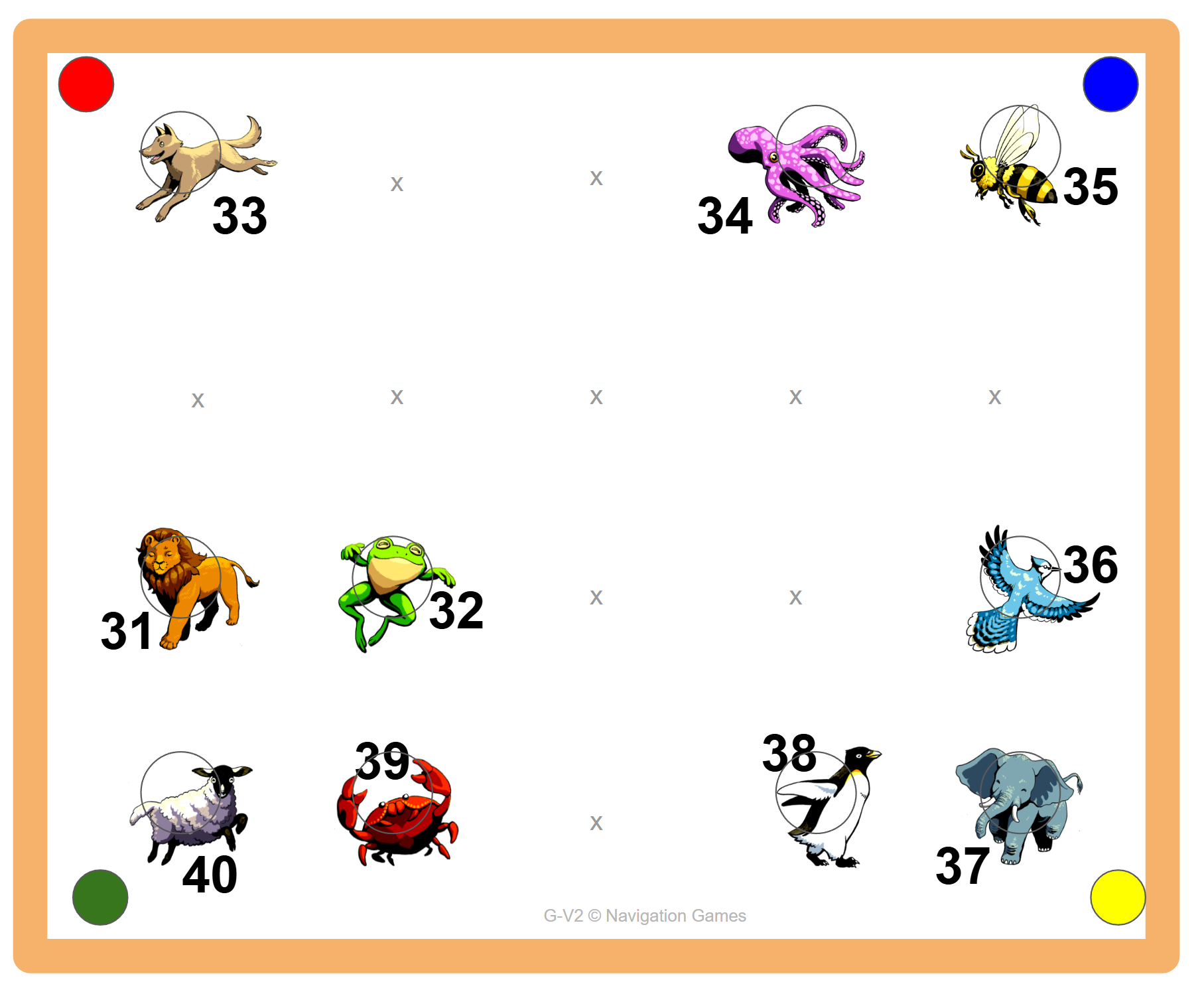
- Arrange checkpoints (cones with animal pictures and numbers 31-40) to match the all-checkpoints map
- Place colored cones (red, blue, green, yellow) in the corners as landmarks. Exact distances do not need to be perfect as long as cones are in the correct positions relative to the colored landmarks
- Draw the arrangement on a whiteboard without indicating which animal is at each location
- Set geometric maps out where students can see them, ideally next to a self-serve station
Steps
1. Whiteboard introduction. Have students gather facing the arrangement:
- Hold up the whiteboard map upside down (not oriented to the cones)
- Quiz students on what the dots represent (orange dots = animal cones, colored dots = colored landmark cones)
- Ask students what is wrong with the map (it is upside down)
- Have students shout "Stop!" as you slowly rotate the map to orient it
- When oriented, show how colored cones on the map match real life, and how animal cone groupings match too
- Point to checkpoints on the map and ask which animal is there. Then point to animals in real life and ask where they are on the map
2. Spatial descriptions. Ask students to find checkpoints based on descriptions of increasing difficulty:
- Easy: "Find the animal closest to the red cone"
- Medium: "Find the animal furthest from the blue cone"
- Hard: "Find all the animals between the yellow and green cone"
3. Geometric courses. Students may work in pairs, sharing one map and switching who holds it after each course:
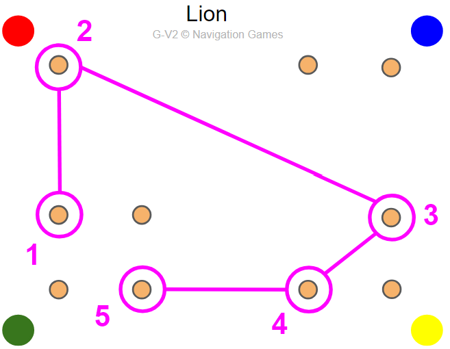
- Pass out 5-checkpoint maps. Each course has an animal name on it. Visit checkpoints in order, starting with the triangle
- The partner with the animal clue sheet can verify correctness
- Progress to 10-checkpoint maps
Adaptations
Ways to adapt the activity to meet the needs of your students: slow things down, increase the challenge, or adapt for different learners
- Younger students: use all levels (1 checkpoint, then 2 on corners, then 2 with one off-corner, etc.)
- Older students: skip to 5-checkpoint maps, then move to 10-checkpoint maps
- For speed: repeat the same course and beat your time
- From memory: put the map away and try to complete the course
- Remove landmarks: take away the colored corner cones for an extra challenge
- Track times: log course completions or times on a whiteboard for friendly competition
- Napkin-O: hide the animal pictures with napkins so students rely on spatial memory and communication (see Related Activities tab)
- Electronic timing: use SPORTIdent or similar timing to track times automatically
Tips
- The whiteboard introduction is essential. Do not skip it. It teaches orientation before students try courses on their own
- Students should always orient their map before starting a course
- If students are struggling, have them match the colored cones first, then find their checkpoint relative to those landmarks
Reflection
- What was challenging about matching up the animals? What was easy?
- How did the colored cones help you orient the map?
- How did you describe where a checkpoint was using words like closest, furthest, or between?
- What sort of mistakes did people make?
- How did you figure out the correct answer?
Script
Introducing the Map
(Hold up the whiteboard map upside down, facing students)
"The challenge in this activity is to find checkpoints using a simple map. In order to do this, we first have to learn how the map works."
"Looking at this map, what do you think the orange dots are?" (Orange cones.) "What about the colored dots?" (Colored cones.)
Orienting the Map
"Now, according to the map, the red cone should be in... this corner!" (Point to the corner opposite of the red cone, since the map is upside down.) "Is the red cone in that corner? Of course not!"
"Even though this map has all the objects, there is still something wrong with it. Can anyone tell me what that is?" (It's not turned right.)
"I'm going to turn the map now, and all of you shout 'Stop!' when the colored dots match up with where they are in real life."
(Turn the map slowly. Stop when students say "Stop" regardless of whether they are correct. Check the colored cones. If not right, acknowledge they are closer and keep turning.)
Using the Map
"Now that our map is oriented, we can see all the colored cones are in the same places in real life as they are on the map. These colored cones are your landmarks, and you can use them to help find the other checkpoints."
"Next I'm going to point to a specific checkpoint on this map, and I want you to point to where that cone is in real life."
(Point to a checkpoint. When they point correctly, explain how they know using spatial vocabulary: "It's the checkpoint closest to the red landmark cone." Repeat 2-3 times.)
Starting the Courses
"For the next game, you will receive a map like this one with several checkpoints marked on it. Your challenge is to find those checkpoints and go visit them. There are several levels of difficulty, so try to get as far as you can!"
Vocabulary
Map: A picture or image used to represent the environment.
Spatial relationship: Where something is based on other features in the space. Vocabulary includes next to, closest, furthest, between.
Orient the map: Turn the map until it matches the space. "Orient" is just a fancy word for "turn things."
Landmark: A distinct object or location in the space. In Geometric-O, the colored cones in the corners are the landmarks.
See the Glossary for all curriculum terms.
Related Activities
Napkin-O (extension)
After students are comfortable with Geometric-O, hide the animal pictures under napkins and give each pair a new clue sheet. They must rely on spatial memory and communicate with other pairs to figure out which animal is at each checkpoint. Builds teamwork, communication, and spatial memory. Takes 15-30 minutes: each pair runs a 5-animal course three times (learning, then speed, then memory) before the napkins go on; give the group 2 minutes to strategize, then start everyone at once.
Basketball-O (extension)
The same concept as Geometric-O, but using the lines of a basketball court as landmarks instead of colored cones. Works well as a next step after Geometric-O because the court provides more complex, real-world landmarks. Takes 30-60 minutes with a basketball court and Basketball-O maps; same progression as Geometric-O, orienting to court features before completing courses of increasing difficulty.
Pacman-O (extension of Basketball-O)
A Pacman-themed version of Basketball-O: students can only travel along the court lines and must avoid "ghosts" (taggers) while visiting checkpoints in order. Adds route planning, strategy, and a competitive element. Takes 30-60 minutes; pair up, orient the map, and assign ghosts (who can't run) before playing, repeating for speed or new courses.
Word Bank Orienteering (variation)
One partner reads the map and directs the runner to checkpoints using only approved words (left, right, next to, corner, middle, between, compass directions). Builds verbal communication and spatial vocabulary alongside the map skills Geometric-O introduces. Takes 15-20 minutes; switch roles after each course.
See Electronic Timing for setup instructions.
Videos
How to teach Geometric-O
Geometric-O in action
Geometric Animal-O
Choose your challenge: a clue sheet or a map!
You can also use electronic timing!
Basketball-O: orienteering on a basketball court